| Name | Last modified | Size | Description | |
|---|---|---|---|---|
| Parent Directory | - | |||
| 1342183062_before_af..> | 2017-05-30 14:28 | 387K | ||
| level2_25/ | 2017-05-30 12:41 | - | ||
| obsidList.csv | 2017-06-06 10:41 | 72K | ||
| postcards/ | 2017-09-06 10:10 | - | ||
| stackedImages/ | 2017-05-30 11:11 | - | ||
The Herschel absolute pointing error is of the order of 2 arcsec (68% c.i.), which is relatively good, compared with the 250 µm beam FWHM of 18 arcsec. Some observations, however, suffered more important pointing offsets.
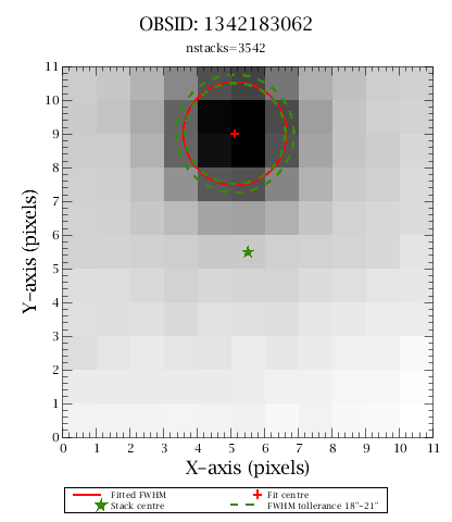
In order to derive the absolute pointing of the SPIRE maps we use the WISE all sky catalogue (Wright et al 2010, Cutri et al. 2012) and stack on the WISE 22 µm sources. We cut a region of 11x11 pixels (66x66 arcsec) from the SPIRE 250 µm map, centred on each WISE 22 µm source and then co-add all the images (see Figure 1). We fit a 2D circular Gaussian to the stack signal, keeping the FWHM fixed. If the median stack signal is a good representation of the beam, then the offset of the centroid of the fitted 2-D Gaussian, with respect to the stack central pixel, is the astrometric shift we need to apply to the SPIRE map.
The stack images for all SPIRE 250 µm level-2 maps are available in stackImages folder.
 |
|
| Figure 1: Example of a good stack signal. The 11x11 pixel map (66”x66”) is composed of 250 µm map cutouts around the positions of 3542 WISE 22 µm sources. The centre of the fitted circular 2D Gaussian is indicated with a red cross, the fixed FWHM is shown as a red circle. The green star is the stack image centre. The green dashed lines are the confidence intervals on the fitted FWHM, in order to consider the stack signal as a good representation of the beam. |
We performed astrometry shifts only for maps, where the derived total offset exceeds 5 arcsec. Once each Level-2 map is corrected, via shifts in the detector timelines, then an updated map is produced with the standard pipeline. When a Level-2 map is part of a larger Level-2.5 map, then the Level-2.5 map is also updated, merging the corrected timelines before the map making.
The list of all Level-2 maps, for which the derived astrometry offset exceeds 5 arcsec, is available in obsidList. Note that there are 109 Level-2 maps, while there are 70 observations with corrected maps in folder level2_25, because some Level-2 maps are part of Level-2.5 maps. The obsidList file has this information in the last column: 'obsidList', where the full list of OBSIDs for each Level-2.5 is provided. In folder level2_25 the FITS files with _map_ in the name are Level-2, while those with _pmd_ are Level-2.5. For example, OBSID 1342183064 is not available in level2_25 folder, because this map is part of Level-2.5 with first OBSID = 1342183062.
Using the original Level-2 maps will only result in offset in source coordinates, while in the extreme cases for Level-2.5, the original maps will have extended or double sources, as shown in Figure 2.
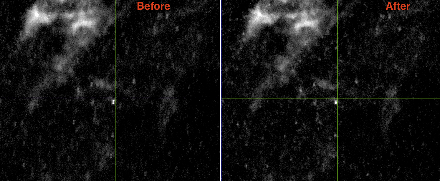 |
| Figure 2: (click to enlarge) Example of before and after the astrometry correction for 1342183062 (Level-2.5 map). The sources on the right (before) are visibly double. |
The astrometrically corrected maps (and timelines) were used in the production of version 3 of the SPIRE Point Source Catalogue.
Wright, E. L., et al., "The Wide-field Infrared Survey Explorer (WISE): Mission Description and Initial On-orbit Performance", AJ 140, 1868, (2010)
Cutri, R. M., et al., "Explanatory Supplement to the WISE All-Sky Data Release Products", 2012
=== Ivan Valtchanov, Herschel Science Centre, May 2017